How does AIS work
How does AIS work ?
AIS - Automatic Identification System
Automatic Identification System (AIS) is a short-range coastal tracking system, currently used on ships. It was developed to provide the identification details and positioning information to all vessels and shore stations using the AIS system.
AIS has been the mariner's most significant development in navigation safety and yacht visibility since the introduction of radar. This is a digital positional awareness system, operating on the Very High Frequency (VHF) maritime radio band. Its purpose is to help identify yachts & ships, assist in target tracking and search and rescue operations. Its design simplifies and assists in fast information exchange and provide additional information to assist situational awareness.
Originally developed as a collision avoidance tool to enable commercial vessels to 'see' each other more clearly in all conditions and improve the helmsman's information about his surrounding environment. AIS does this by continuously transmitting a vessels identity, position, speed and course along with other relevant information to all other AIS equipped vessels within range. Combined with a shore station, this system also offers port authorities and maritime safety bodies the ability to manage maritime traffic and reduce the hazards of marine navigation.
AIS Range of Visibility
The range of reception for commercial Class - A AIS can be variable and is dependent on factors including signal propagation conditions, sea state, the height of the transmitting and receiving antenna and the strength of the vessel transmitter. Reception could be as little as 20 nautical miles on inshore areas like the Solent, or up to as much as 350 nautical miles for powerful transmissions during appropriate atmospheric conditions. Most offshore AIS reception ranges, it is considered likely that on average, a 40 nautical mile reception radius will be achieved by an AIS receiver network.
AIS Class -B has a much smaller power output to class - A with ranges of up to 10 nautical miles but works in much the same way with conditions changing range.
How AIS Works
AIS works by taking your position and movements via the vessels' GPS system or an internal sensor built into an AIS unit. That information is then collated along with programmable information from the AIS unit (e.g. Maritime Mobile Service Identity (MMSI) number, vessel name, destination, cargo type) and is transmitted in the background at regular intervals whilst also receiving other vessels AIS information. The AIS unit can have its own separate antenna or an antenna splitter can be used from the antenna the VHF radio transmits from. If an antenna splitter is used, it must be an active splitter suitable for a VHF radio and AIS transponder.
AIS types and what is the difference
- Class A: Mandated for all vessels 300 GT and above engaged on international voyages as well as all passenger ships
- Class B: Provides limited functionality and is intended for non-SOLAS vessels. Primarily used for vessels such as pleasure crafts
AIS operates principally on two dedicated frequencies or VHF channels:
- AIS 1: Works on 161.975 MHz- Channel 87B (Simplex, for the ship to ship)
- AIS 2: 162.025 MHz- Channel 88B (Duplex for the ship to shore)
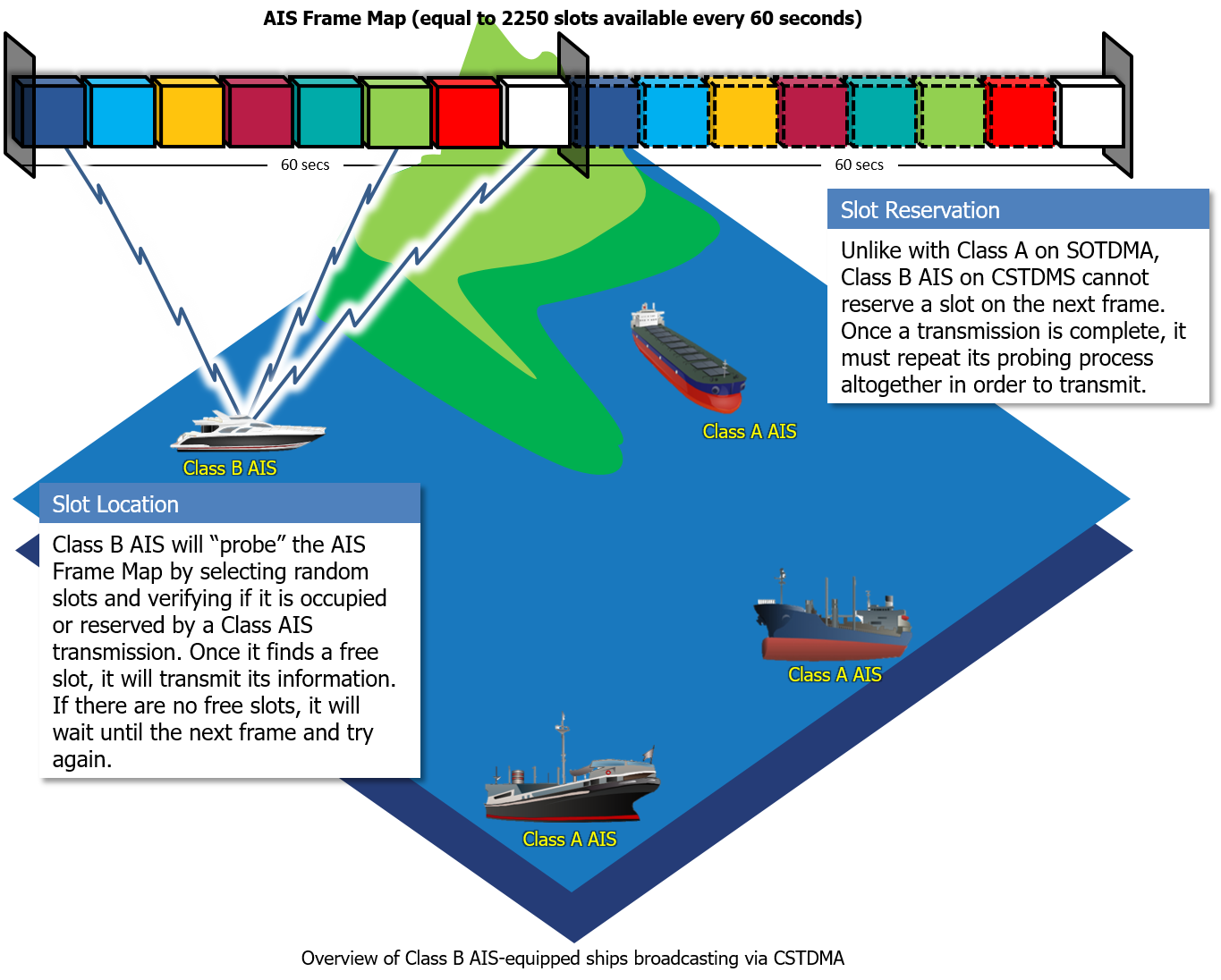
Every 60 seconds the AIS system creates 2250 transmission slots - or 1 every 29 milliseconds. Class - A vessels always has priority over the slots available and after each transmission from a commercial vessel, it then reserves its next slot in the next 60 second window and this continues 24 hours a day wherever it is in the world within its transmission range. Class - B vessels search for the spare unreserved slots in amongst the 2250 available slots to transmit their information. In busy areas like the Solent the number of boats present at sea, along with the busy commercial traffic in the channel and surrounding ports can cause delays in transmission for many Class - B transceivers causing a lag of information on sites like marine traffic and jumping targets on yacht chart plotters
AIS DATA transmitted
1. Static Information (Every 6 minutes and on request):
- MMSI number
- IMO number
- Name and Call Sign
- Length and Beam
- Type of ship
- Location of position fixing antenna
2. Dynamic Information (Depends on speed and course alteration)
- Ship's position with accuracy indication
- Position timestamp (in UTC)
- Course Over Ground (COG)
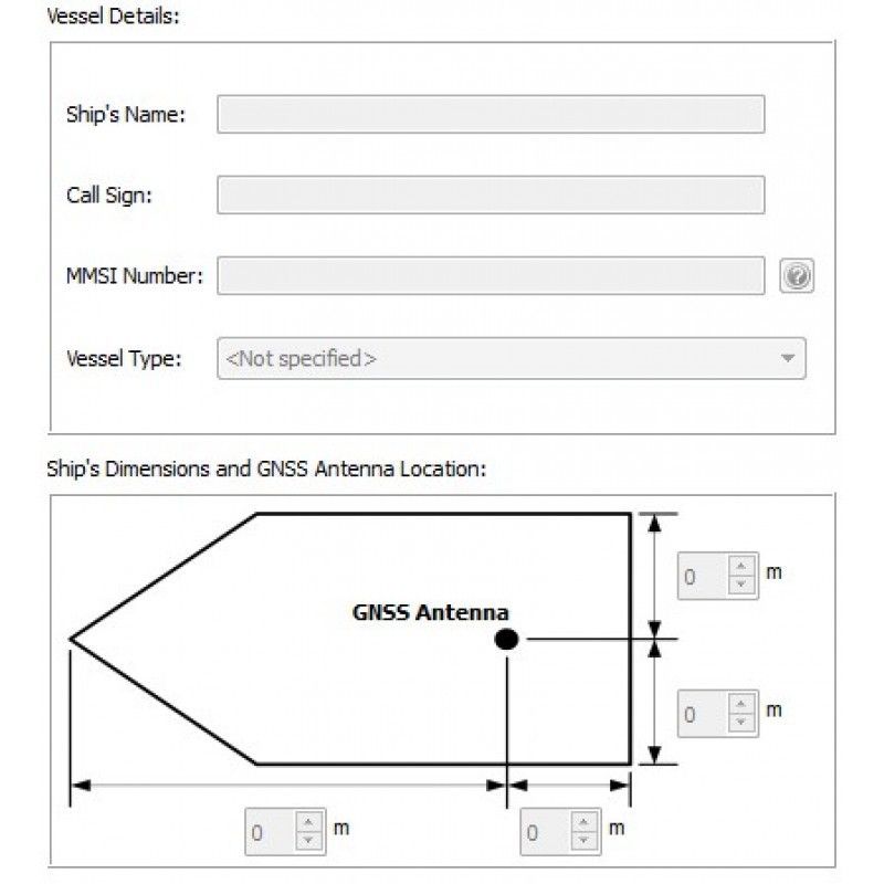
Programming a Class-B AIS transceiver
If you only have an AIS receiver only then you will not need to program your unit, if yours transmits, most manufacturers create a similar looking software the picture below that all ask for the same information. You will always be asked to enter your MMSI number twice to confirm it is correct, if you enter it incorrectly, it cannot be changed, unless you remove the unit and send it back to the manufacturer in most cases for a fee.
All the required details will be in your letter from Ofcom in your returned application for an MMSI number, these details are
- Vessel Name
- Call Sign
- MMSI Number
Then you will need to add the type of vessel it is, sailing yacht, motorboat etc. Then it asks for the precise dimensions of your vessel in meters alone, don't add centimetres or points as sometimes the program will makes it into 1 large number, that then creates a huge green target hundreds of meters long, that everyone can see on their AIS displays - it has been done in the solent and only other people can see it. Then for precise locating, you need to add the location of the gnss antenna on the boat, in meters from the bow or aft and from port to starboard, its quite often these are glued to the underside of the deck near the AIS unit in the chart table area.
Maritime security
AIS enables authorities to identify specific vessels and their activity within or near a nation's Exclusive Economic Zone. When AIS data is fused with existing radar systems, authorities are able to differentiate between vessels more easily. AIS data can be automatically processed to create normalized activity patterns for individual vessels, which when breached, create an alert, thus highlighting potential threats for more efficient use of security assets. AIS improves maritime domain awareness and allows for heightened security and control
AIS should not be switched off, save for very few exceptions. AIS should always be in operation when yachts fitted with it are underway or at anchor. A yachts crew may turn off its AIS broadcast for a variety of legitimate reasons, but this behavior may indicate that a vessel is hiding its location and identity to conceal illegal activities which if already flagged, can alert local authorities.
New Paragraph